Green River
Overview
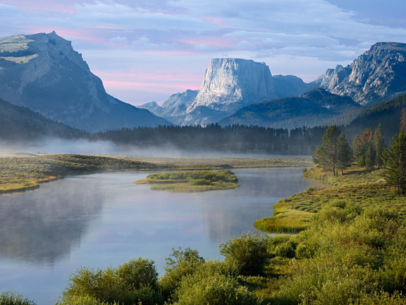
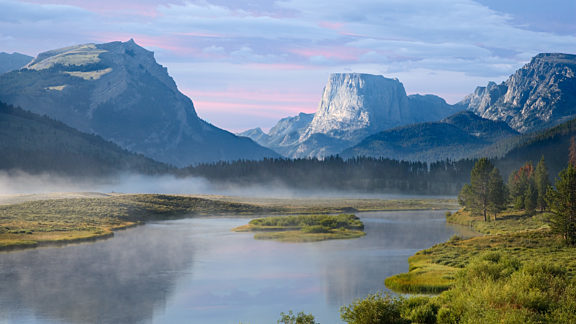
The Green River, a major tributary (and some say, the true source) of the great Colorado River system, is born from the meltwater of Pinedale, Wyoming’s Wind River Mountains. From Green River Lakes, the Green River runs 730 miles to join Colorado deep in Utah’s Canyonlands National Park. The Green River is not only one of the major waterways of the Rocky Mountain West, but it is also Pinedale’s agricultural lifeline, the recreational crown jewel, and the basis of most of the region’s early history.
Popular Activities
History of the Green River
Native Americans came to the Green River Valley seasonally for the game, as evidenced by the remains of buffalo jumps and kill sites. Adventurers like the Astorian group led here by William Price Hunt in 1811, found the place excellent for restocking their food stores and recuperating. Fur trappers and mountain men wrestled a dangerous living from it, celebrating their survival at several Rendezvous on the Green River at Horse Creek.
Parched pioneers crossed it on the Oregon Trail, and tie hacks in 1867 sent their first harvest of logs floating on it to the railroad 130 miles south. For more than a century, ranchers have produced Sublette County’s only successful and sustainable cash crops — hay and livestock — by diverting precious rations of its water into their fields.
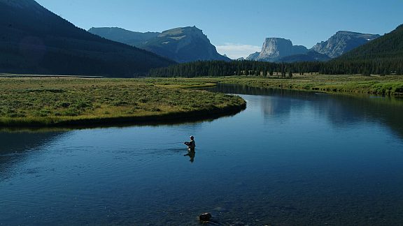
Fishing
Today visitors come to play on the Green, whether for fishing, floating, hunting, camping, or just enjoying the scenery. Anglers can hook Brook Trout, Brown Trout, Cutthroat, Mackinaw (lake trout), Rainbows, and Mountain Whitefish. Public access areas along the river’s course are numerous and supervised by the Wyoming Game & Fish Department. Local commercial guides are also available for float and fishing trips on the Green. They are well acquainted with the regulations, the river, and the best times and places to be on it.
Beginning in the Bridger-Teton National Forest at Green River Lakes, the river makes a big bend and then turns south before entering private property. Unpaved National Forest roads skirt the river and afford many places along this 20-mile stretch to fish, watch wildlife, and enjoy the sound of tumbling water. Whiskey Grove Campground, about a 30-minute drive from Green River Lakes, is an ideal fishing camp next to the river with 9 sites. Most sites have a view of the water. There are vault toilets, fire grates, picnic tables, and drinking water (except in periods of drought). There are no trailer pull-throughs or horse facilities, and the campground can fill up quickly during holidays.
Green River Wildlife
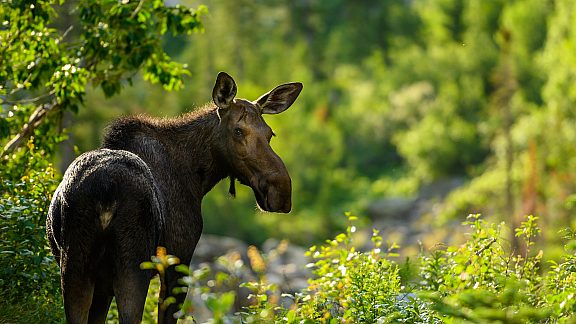
Abundant wildlife continues to thrive all along the river’s course, from wild fish (including the rare Kendall Warm Springs dace) shading below its overhanging banks to moose browsing the willows and osprey and eagles perched in the tall cottonwoods all along the floodplain. Ducks circle in the current, herons stalk the shallows, sandhill cranes bob and dance in the meadows and killdeers skitter over the mud. Sage grouse, pronghorn, and deer come in from the dry hills for a drink or to find a cool humid spot in the hayfields. And of course, the coyote chorus sings the river’s praise at dawn and dusk.
Public Access Boat Launches
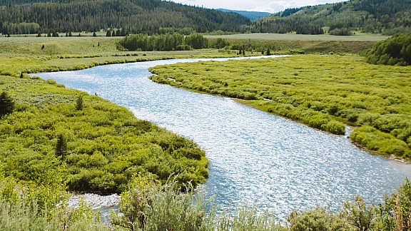
After the Green River exits the National Forest, public access boat launches provided by the Wyoming Game and Fish Department offer numerous opportunities for boaters to spend a day floating down different sections of the river. Boaters park a vehicle and boat trailer or otherwise arrange for pickup at the desired take-out point, then launch from a designated put-in upriver.
Warren Bridge to Huston
A good day-long float would start at one of the accesses north of Warren Bridge on US Highway 191, about eight miles north of the Daniel Junction. Float down to the 40 Rod Creek/Daniel Fish Hatchery access, west of Highway 191 on the Pape Road. Another trip would begin at the private boat access near the Daniel Junction, which can be used after paying a small fee at Stanley’s Junction Conoco, where US Highway 191 meets 189 west of Pinedale. Using this access will allow you to enjoy a very scenic day-long float to the Huston access, about 10 miles downriver. This boat launch is located off County Road 110, which meets Highway 191 at the Cora Y. Turn south off 191 onto this gravel road and drive about 4 miles, until you see a house hugging the right side of the road, on a bluff overlooking the river. Go past the house and over the hill. The Huston access is at the base of the hill, on the right.
Sommers Access to Piney Cutoff
About 3.5 miles further down County Road 110, but about five river miles south, the Sommers public access provides parking and boat launch within a caged easement on a private cattle ranch. The turnoff is marked with a green street sign and you will see ranch buildings and corrals immediately beyond the sign, with a lane leading to the river and a large metal bridge. The boat launch is southeast of the bridge, on the near side of the river. This access is closed April 1st — May 1st to protect cows with very young calves from disturbance. After the Sommers Access, there is no public access to the river for more than twelve miles, until the Piney Cutoff boat launch on the northeast side of the Highway 351 bridge. Depending on water speed and other conditions, the Sommers access is usually used as a take-out point, because the next stretch of river is too long for a day-long float trip and offers few primitive camping areas on public land for an overnight stay.
South of Big Piney
South of Big Piney is several undeveloped boat launch and fishing areas on the Green River. Take US Highway 189 south of Big Piney for 5 miles, then turn left (east) and continue 4 miles northeast to the river at 5 Mile Bridge. The roads and access points along the river in this area are slated for improvement by late 2003. Until then, they useable only in dry conditions. Fishermen should be advised that rain and snowmelt can turn these roads to deep gumbo mud.